Sunday, 27 May 2012

Shadow People

Shadow people are supernatural shadow-like humanoid figures that, according to believers, are seen flickering on walls and ceilings in the viewer's peripheral vision. They are often reported moving with quick, jerky movements, and quickly disintegrate into walls or mirrors. They are believed to be evil and aggressive in nature, although a few people consider them to be a form of guardian angel.

In 2010, the apparitions were described as one of the most regularly reported paranormal phenomena in the United States. This is attributed to occasional reports on the Coast to Coast AM show, where paranormal researcher Heidi Hollis has been interviewed several times on the subject of shadow people. Hollis believes that shadow people have always existed, that they feed upon emotions of fear, and that they can be repelled by thinking positively. Others believe that shadow people may be the extra-dimensional inhabitants of another universe.

The stories of shadow people have been compared to those of the Raven Mocker, a witch from Cherokee mythology who sometimes appears as a shadowy phantom, and the Islamic Jinn.

Several scientific principles can be used to explain reports of apparitional experiences such as shadow people. These include optical illusions or hallucinations brought on by physiological or psychological circumstances, drug use or side effects of medication, and the interaction of external agents on the human body. Another reason that could be behind the illusion is sleep deprivation, which may lead to hallucinations.

Shadow people are always seen in groups, they are usually darker than dark!


Friday, 25 May 2012

The Bermuda Triangle

The Bermuda, or Devil’s, Triangle is an area of ocean found off the south-eastern tip of the United States. It is a region of water indelibly connected with mysterious vessel disappearances; the popular perception is that countless boats and planes have been inexplicably lost there. The triangle extends from Bermuda to Miami and then to the Puerto Rico, and is said to contain a supernatural secret. Some high profile disappearances have occurred there, and the notion of its existence has been turned into a modern myth in the media. Even the term ‘Bermuda Triangle’ was coined in a fictional publication. But does the sea here really house some unknown power that pulls sea and airmen to their doom, or is this mystery based mainly on imagination?

The most famous loss in the triangle is known as the mystery of Flight 19, and happened on 5th December 1945. A squadron of five US Navy Avenger torpedo bombers set off from their base in Fort Lauderdale, Florida to conduct a practice mission over the island of Bimini. The flight contained 14 men, all of them students apart from the commander, Lt Charles Taylor. About an hour and a half after the mission began, radio operators received a signal from Taylor saying his compasses were not working, but he believed he was over the Florida Keys. He was advised to fly north which would bring him back to the mainland. In fact, he was over the Bahamas, and his attempts to head north and north-east merely took him further away from solid ground. A terrible storm that day hampered communications and it seems Taylor rejected a suggestion to pass control of the squadron to one of the other pilots.

Radio contact was entirely lost and search craft were dispatched to try and find the flight to guide them back in. Of the three planes used to rescue Flight 19, one lost communications itself because of an iced over aerial, one was just unsuccessful whilst another seemed to explode shortly after takeoff. Flight 19 itself has never been found, but it is assumed that they ditched into the raging sea when their fuel ran out, with the heavy planes rapidly sinking to the ocean floor. The US Navy recorded that the disaster was caused by Taylor’s confusion, but an appeal by his family had this overturned, and a verdict of ‘causes or reasons unknown’ was given. However, Flight 19 is not the only high profile official loss in the area, and the USS Cyclops and Marine Sulphur Queen have also disappeared without trace.

The legend of Flight 19 was cemented by its inclusion in Steven Spielberg’s Close Encounters of the Third Kind movie. Indeed, some theories state that visiting UFO craft enter an underwater base in the Bermuda area, and they have been the cause of the disappearances. Other fantastical ideas such as technologies from Atlantis or evil marine creatures have also been considered. Some people even suggest the triangle is the site of a gateway into another dimension. Strange oceanographic features such as huge clouds of methane gas escaping from the seabed have also been blamed for the disappearances.
In reality, the triangle does have one natural quality which may contribute to the losses. Unlike everywhere else in the world (apart from the Dragon’s Triangle near Japan) compasses point to true north rather than magnetic north. This may be a contributing factor to the triangle’s legend, but the US Coastguard officially believes the losses are caused by a mixture of environmental and man-made mistakes. This region is used by a large amount of ocean and air traffic, much of which is navigated by inexperienced pleasure-seekers. A strong Gulf Stream and unpredictable weather conditions not only cause vessels to run into trouble, but also remove many traces of them once they have been wrecked.

It is interesting also to note that the coastguard does not view the area as having a particularly high incidence of accidents. One researcher examined many historic losses in the triangle. He came to the conclusion that rumours and elaboration had clouded the real, understandable, causes behind the events. Similarly, the international insurers, Lloyd’s of London, have records that demonstrate that this region near Bermuda is no more treacherous than any other waterway. However, the myth of the Bermuda Triangle is so strong it will live on as long as fictional writers use it as a site of mysterious happenings.

Wednesday, 23 May 2012

The 14 foot wombat: First complete skeleton of prehistoric monster found in Australia

  • The diprotodon weighed three tons and was 14ft long 
  • It lived between 25,000 and two million years ago 
It did not eat flesh, but whatever got in its way would have been trampled to death, scientists agreed today after the first complete skeleton of a prehistoric monster was found in Australia.

Known as a diprotodon and likened to a giant wombat, weighing three tons and stretching up to 14ft long, it roamed the Australian continent between 25,000 and two million years ago.

What is known, from a fragment of bone from the remains of another diprotodon discovered in New South Wales, is that these creatures lived on the continent at the same time as the early Aborigines.


Reconstruction: The first complete skeleton of a prehistoric monster has been found by scientists in north-west Queensland, Australia

A small hole was found in that fragment, suggesting that the animal was brought down by a spear.

But that was just one bone and, until the latest discovery in north-west Queensland's Gulf of Carpentaria region, a complete skeleton had not been found.

'We hope we will now be able to reconstruct the bones, put them into their original positions, to give us a pretty good idea of what these creatures looked like,' said Professor Michael Archer of the Australian Museum, who has travelled to a cattle station where the skeleton was found.

Although artists have painted what scientists believe would be images of the diprotodon, the discovery of the complete skeleton will help in revealing more of the creature's shape and size.

'What we're seeing here is the biggest marsupial (an animal that carries its young in a pouch) that ever lived in the world - a three-ton monster,' said Professor Archer.

'This here in Queensland was its last stand, judging by the relatively undamaged complete skeleton.'

Professor Archer said it was unusual for all the bones of ancient creatures to be found in one place.


A reproduction of aboriginal rock art depicting a diprotodon. It was found in Northern Australia and is believed to be 10,000 years old

'All the bones are not necessarily in their right position, but probably the whole skeleton of this giant is in this one spot where it fell maybe 50,000 years ago.

'There was just one little bone sticking out - and then we found the rest.'

Diprotodons were widespread across Australia when the first indigenous people arrived some 50,000 years ago from what is today South-East Asia.

The heavily-built animals fed on grasses but they might not have been too intelligent - although having an oversized skull, it was filled with numerous air spaces.

Until the Queensland discovery, the most complete specimen was found at Tambar Springs in New South Wales.

Scientists were excited to discover that on one rib there was a small square hole, believed to have been made by a spear while the bone was still fresh.

Now palaeontologists are hoping that more clues about the creature will be found in the newly-discovered Queensland bones.


Find: The skeleton was discovered in north-west Queensland's Gulf of Carpentaria region


Read more: http://www.dailymail.co.uk/sciencetech/article-2011107/Giant-wombat-skeleton-Australia-Prehistoric-Diprotodon-14-foot.html#ixzz1qSQc9cD0

Oldest animal with a skeleton discovered

It's 560 million years old and provides a crucial insight into the evolution of life

At between 550 and 560 million years old, an animal discovered in South Australia recently is the oldest with a skeleton ever found.

The organism, called Coronacollina acula, was found by a team from the University of California.

The finding provides insight into the evolution of life – particularly, early life – on the planet, why animals go extinct, and how organisms respond to environmental changes.


Rock on: These are the best Coronacollina specimens showing the main body with articulated spicules

The discovery also can help scientists recognise life elsewhere in the universe.

Coronacollina acula lived on the seafloor. It was shaped like a thimble with at least four 20 to 40-centimetre-long spikes called ’spicules’ attached. These probably held the creature up.

The researchers believe it ingested food in the same manner a sponge does, and that it was incapable of moving around. How it reproduced remains a mystery.


How Coronacollina would have appeared in life: It remained in place on the sea floor and may have used its spicules as support struts

Its age places it in the Ediacaran period, before the explosion of life and diversification of organisms took place on Earth in the Cambrian, 488 to 542 million years ago.

‘Up until the Cambrian, it was understood that animals were soft bodied and had no hard parts,’ said Mary Droser, lead researcher and a professor of geology at the University of California.

‘But we now have an organism with individual skeletal body parts that appears before the Cambrian. It is therefore the oldest animal with hard parts, and it has a number of them - they would have been structural supports - essentially holding it up. This is a major innovation for animals.’

Coronacollina acula is seen in the fossils as a depression measuring a few millimetres to two centimetres deep. But because rocks compact over time, the organism could have been bigger – three to five centimetres tall. Notably, it is constructed in the same way that Cambrian sponges were constructed.

‘It therefore provides a link between the two time intervals,’ Droser said. ‘We're calling it the “harbinger of Cambrian constructional morphology”, which is to say it's a precursor of organisms seen in the Cambrian. This is tremendously exciting because it is the first appearance of one of the major novelties of animal evolution.’

According to Droser, the appearance of Coronacollina acula signals that the initiation of skeletons was not as sudden in the Cambrian as was thought, and that Ediacaran animals like it are part of the evolutionary lineage of animals as we know them.

‘The fate of the earliest Ediacaran animals has been a subject of debate, with many suggesting that they all went extinct just before the Cambrian,’ she said. ‘Our discovery shows that they did not.’

Results of the study appeared online recently in Geology.


Read more: http://www.dailymail.co.uk/sciencetech/article-2112532/Coronacollina-acula-Oldest-animal-skeleton-discovered.html#ixzz1qSE5NsSK

Oldest Skeleton of Human Ancestor Found

Oldest Skeleton of Human Ancestor Found

Move over, Lucy. And kiss the missing link goodbye.

Scientists today announced the discovery of the oldest fossil skeleton of a human ancestor. The find reveals that our forebears underwent a previously unknown stage of evolution more than a million years before Lucy, the iconic early human ancestor specimen that walked the Earth 3.2 million years ago.

The centerpiece of a treasure trove of new fossils, the skeleton—assigned to a species called Ardipithecus ramidus—belonged to a small-brained, 110-pound (50-kilogram) female nicknamed "Ardi." (See pictures ofArdipithecus ramidus.)

The fossil puts to rest the notion, popular since Darwin's time, that a chimpanzee-like missing link—resembling something between humans and today's apes—would eventually be found at the root of the human family tree. Indeed, the new evidence suggests that the study of chimpanzee anatomy and behavior—long used to infer the nature of the earliest human ancestors—is largely irrelevant to understanding our beginnings.


Skeleton found of man killed by arrowhead 1,000 years ago


THE SKELETON of a young man killed 1,000 years ago by an iron arrowhead found in his skull has been unearthed by archaeologists in east Galway.

The shallow grave with the man’s body was discovered by a farmer during recent quarrying work near Newcastle village.

During further examination, the iron arrowhead which claimed his life was retrieved from inside his skull.

Traces of an underground passage dating from the ninth century have also been identified in the same section of quarry face in the townland of Tisaxon near Newcastle, according to archaeologist Martin Fitzpatrick of Arch Consultancy Ltd.

Mr Fitzpatrick’s team was called in after the find was reported to the Department of Arts, Heritage and the Gaeltacht. Archaeological work was co- funded by that department and the Department of the Environment.

Mr Fitzpatrick estimated the man was aged between 17 and 25, and may have been buried after a battle in this esker area. “The fact that he was lying east-west indicates that he was buried, and it is clear that he had already died of his injury,” he said.

The man was placed on his side in a crouched position. His feet are missing – possibly removed inadvertently during mechanical excavation or during slippage of the quarry face.

Osteoarchaeologist Caoimhe Tobin confirmed the head wound was inflicted by a small iron arrowhead of about four centimetres in length, and preliminary analysis suggests it dates back to the ninth or 10th century.

Mr Fitzpatrick said the passage was the “creep” of a souterrain or underground chamber used for refuge and storage – often associated with ring forts from the ninth century on.

“While there is no ring fort associated with this souterrain, the ecclesiastical site of Templemoyle lies to the immediate east,” he said.

Templemoyle has an early ecclesiastical enclosure, a well, church and cemetery.

Since 1952, burials have been uncovered during quarrying for sand and gravel in this locality. In 1979 a grave slab with the inscription “Oroit ar maelpoil” and a large bronze-coated iron hand bell dating between the seventh and ninth centuries were discovered.


1400-YEAR-OLD SKELETON OF ONE OF UK'S FIRST CHRISTIANS

Scientists have discovered the remains of what is thought to be one of Britain's first ever Christians after unearthing an "excessively rare" 1400-year-old Anglo-Saxon burial site in Cambridgeshire.

Yahoo! UK reports the grave contains the skeletal remains of a 16-year-old female Catholic lying on an ornamental bed clutching a gold and garnet cross – suggesting she was one of Britain’s earliest Christians.

Quite how the 16-year-old Anglo Saxon girl died remains a mystery but it is believed that she was a member of nobility and persuaded to join the Christian faith after the Pope dispatched St Augustine to England in 597AD.

Dr Sam Lewsey, an expert on the period, told Yahoo! UK: "This is an excessively rare discovery. It is the most amazing find I have ever encountered.


The 1400-year-old remains of what is thought to be one of Britain's first ever Christians.

"Christian conversion began at the top and percolated down. To be buried in this elaborate way, with such a valuable artefact, tells us that this girl was probably nobility or even royalty.

"This cross is the kind of material culture that was in circulation at the highest sphere of society."


Source: http://au.news.yahoo.com/odd/a/-/odd/13197669/amazing-find-1400-year-old-skeleton-of-one-of-uks-first-christians/

10 Unfortunate Things That Happened On Friday 13th


Friday 13th has always been considered luck by some and not so lucky for others. Here's a list of 10 unfortunate things that happened on Friday 13ths. By the way, how was your Friday 13th?  


Video owned by alltime10s

A man with two faces - Edward Mordrake


The true tale of Edward Mordrake has been lost to history. His unusual case occurred early in medical history and is referenced only in tales handed down. The tale of his life has become so muddled through the passage of time that no solid date of birth or death is evident to modern researchers.

The story always begins the same way. Edward is said be have been heir to one of the noblest families in England. He was considered a bright and charming man – a scholar, a musician and a young man in possession of profound grace. He was said to be quite handsome when viewed from the front – yet, on the back of his head there was a second face, twisted and evil.

In some versions of the story, the second face of Edward is a beautiful girl.This is an impossibility as all parasitic twins are of the same sex. Often it was said that it possessed its own intelligence and was quite malignant in its intentions.It has been said that the eyes would follow spectators and its lips would ‘gibber’ relentlessly and silently. According to legend it would smile and sneer as Edward wept over his condition.While no voice was ever audible, Edward swore that often he would be kept awake by the hateful whispers of his ‘evil twin’.

The story has always concluded with young Edward committing suicide at the age of twenty-three.The method of his death also differs, sometimes poison does him in and in other versions a bullet ‘between the eyes of his devil-twin’ puts him out of his misery. In both versions Edward leaves behind a letter requesting that the ‘demon face’ be destroyed before his burial, ‘lest it continues its dreadful whisperings in my grave.’


NASA Finds Lost Spacecraft on Dark Side of the Moon

Impact Site
Photo via NASA
NASA scientists have found the crash site, pictured above, of a spacecraft set into orbit during the early 60s. This one–thankfully–is not crawling with Decepticons. They believe it is the missing Lunar Orbiter 2which disappeared back in 1967 during a passage over the far side of the moon, when the craft went out of telescope and radio range.

Lunar Orbit 2′s primary function was documenting areas of the moon that would be most hospitable to the Apollo and Surveyor missions. During its run, it returned a total of 609 high resolution images and 208 medium-sized frames. This includes the Copernicus crater (pictured below) which is considered by many to be the Picture of the Century.

Picture of the Century
Photo via NASA

While the spacecraft was intentionally downed on October 11, 1967, scientists had yet to find the crash site–til now.

The wreckage is thought to have been located by the Lunar Reconnaissance Orbiter (LRO) which is currently mapping the lunar surface in unprecedented detail. During its mission so far, the spacecraft has gathered more than 192 terabytes of data; that’s nearly 41,000 DVDs worth of data, images and maps! One of its key findings is our solar system’s coldest spot: a crater near the moon’s north pole was recorded at minus 415 degrees Fahrenheit. Brrr!

Some of the images LRO has captured can be seen below, but you can also find more here.
Crater in Mare Humorum
Photo via NASA
Dark Streaks in Diophantus Crater
Photo via NASA
Source: Discovery

Archaeologists discover Jordan’s earliest buildings

Some of the earliest evidence of prehistoric architecture has been discovered in the Jordanian desert, providing archaeologists with a new perspective on how humans lived 20,000 years ago.


Archaeologists working in eastern Jordan have announced the discovery of 20,000-year-old hut structures, the earliest yet found in the Kingdom. The finding suggests that the area was once intensively occupied and that the origins of architecture in the region date back twenty millennia, before the emergence of agriculture.

The research, published 15 February, 2012 in PLoS One by a joint British, Danish, American and Jordanian team, describes huts that hunter-gatherers used as long-term residences and suggests that many behaviours that have been associated with later cultures and communities, such as a growing attachment to a location and a far-reaching social network, existed up to 10,000 years earlier.

Excavations at the site of Kharaneh IV are providing archaeologists with a new perspective on how humans lived 20,000 years ago. Although the area is starkly dry and barren today, during the last Ice Age the deserts of Jordan were in bloom, with rivers, streams, and seasonal lakes and ponds providing a rich environment for hunter-gatherers to settle in.

“What we witness at the site of Kharaneh IV in the Jordanian desert is an enormous concentration of people in one place,” explained Dr Jay Stock from the Department of Archaeology and Anthropology at the University of Cambridge and co-author of the article.

“People lived here for considerable periods of time when these huts were built. They exchanged objects with other groups in the region and even buried their dead at the site. These activities precede the settlements associated with the emergence of agriculture, which replaced hunting and gathering later on. At Kharaneh IV we have been able to document similar behaviour a full 10,000 years before agriculture appears on the scene.”


Stone tools discovered in Arabia force archaeologists to rethink human history

 The tools found in southern Arabia date from 125,000 years ago – 55,000 years before humans were thought to have left Africa


A spectacular haul of stone tools discovered beneath a collapsed rock shelter in southern Arabia has forced a major rethink of the story of human migration out of Africa. The collection of hand axes and other tools shaped to cut, pierce and scrape bear the hallmarks of early human workmanship, but date from 125,000 years ago, around 55,000 years before our ancestors were thought to have left the continent.

The artefacts, uncovered in the United Arab Emirates, point to a much earlier dispersal of ancient humans, who probably cut across from the Horn of Africa to the Arabian peninsula via a shallow channel in the Red Sea that became passable at the end of an ice age. Once established, these early pioneers may have pushed on across the Persian Gulf, perhaps reaching as far as India, Indonesia and eventually Australia.

Michael Petraglia, an archaeologist at Oxford University who was not involved in the work, told the Science journal: "This is really quite spectacular. It breaks the back of the current consensus view."

Anatomically modern humans – those that resemble people alive today – evolved in Africa about 200,000 years ago. Until now, most archaeological evidence has supported an exodus from Africa, or several waves of migration, along the Mediterranean coast or the Arabian shoreline between 80,000 and 60,000 years ago.

A team led by Hans-Peter Uerpmann at the University of Tübingen in Germany uncovered the latest stone tools while excavating sediments at the base of a collapsed overhang set in a limestone mountain called Jebel Faya, about 35 miles (55km) from the Persian Gulf coast. Previous excavations at the site have found artefacts from the iron, bronze and neolithic periods, evidence that the rocky formation has provided millennia of natural shelter for humans.

The array of tools include small hand axes and two-sided blades that are remarkably similar to those fashioned by early humans in east Africa. The researchers tentatively ruled out the possibility of other hominins having made the tools, such as the Neanderthals that already occupied Europe and north Asia, as they were not in Arabia at the time.

The stones, a form of silica-rich rock called chert, were dated by Simon Armitage, a researcher at Royal Holloway, University of London, using a technique that measured how long sand grains around the artefacts had been buried. Another strand of the archaeologists' work, described in Science, focused on climate change records and historical sea levels in the area. They show that between 200,000 and 130,000 years ago, a global ice age caused sea levels to fall by up to 100 metres, while the Saharan and Arabian deserts expanded into vast, inhospitable wastelands.


Read more at theguardian

Ancient City of Akrotiri (Santorini)

Akrotiri is the name of an excavation site of a Minoan Bronze Age settlement on the Greek island of Santorini, associated with the Minoan civilization due to inscriptions in Linear A, and close similarities in artifact and fresco styles. The excavation is named for a modern Greek village situated on a hill nearby. The name of the site in antiquity is unknown.

Akrotiri was buried by the widespread Theran eruption in the middle of the second millenniumBC (during the Late Minoan IA period); as a result, like the Roman ruins of Pompeii after it, it is remarkably well-preserved. Frescoes, pottery, furniture, advanced drainage systems and three-story buildings have been discovered at the site, whose excavation was started in 1967 bySpyridon Marinatos.

Certain historians hold this settlement, as well as the disaster that left it unknown to most of history, as the inspiration behind Plato's story of Atlantis, as mentioned in his dialogues Timaeusand Critias. Excavated artifacts have been installed in a museum distant from the site (Museum of Prehistoric Thera), with many objects and artworks presented. Only a single gold object has been found, hidden beneath flooring, and no uninterred human skeletal remains have been found. This indicates that an orderly evacuation was performed with little or no loss of life.


An ambitious modern roof structure, meant to protect the site, collapsed just prior to its completion in 2005, killing one visitor. No damages were recorded to the antiquities. As a result of this, the site was closed to visitors. As of 2011, it was still closed, with a new roof yet to be built.


Source: Wiki

Ancient City of the Mesa Verde (Cliff Palace)

The Palace in the Cliff
The year was 1888 and the month was December. Two cowboys, Charlie Mason and Richard Wetherill, rode through the falling snow of southwest Colorado looking for stray cattle. They soon came to the edge of a rocky canyon. Looking down into it they made an amazing discovery. On the other side of the canyon was an immense cave cut into the cliff wall, and inside that cave was what looked like a palace. It was the lost city of Mesa Verde we now call Cliff Palace.

Mesa Verde means "Green Table" in Spanish and it is an appropriate name. This part of Colorado is a flat tableland some 20 miles long and 18 miles wide. The top is some 2,000 feet higher than the surrounding land. To the south the Mesa is cut by some 20 canyons which contain over 500 hundred Indian ruins, of which Cliff Palace is the largest.


Archaeologists estimate that the native Americans who built Cliff Palace arrived in Mesa Verde as early as 1 A.D. They apparently lived a quiet and peaceful life on the Mesa tops until about 1200 A.D. when suddenly they abandoned their towns and built new ones in caves on the cliff faces. Why? Probably for security. The caves were large (the cave at Cliff Palace is one-hundred feet deep and three-hundred feet wide) and gave protection from the sun, rain, snow and human enemies.

Cliff Palace has over two-hundred rooms and some parts are three stories high. It probably housed around 400 people. Though the residents lived in the cave, they commuted to the Mesa top to work their agricultural fields.

Around 1280, though, the Indians suddenly abandoned their cliff dwellings and moved away. There is no sign that they were forced out by war, so what could have made the residents leave their new cities barely 80 years after they had been built?

In this case scientists think they have found the answer in the trees of the Mesa. When a tree is cut down, the cross section shows a series of concentric rings. One new ring is laid down each year. By counting the rings it is possible to tell the age of the tree. By looking at the width of the ring it is possible to tell how much a tree grew in any particular year.

By examining trees, scientists have been able to determine that a severe drought hit the Mesa around 1276 and lasted 24 years. This affected the residents food supply and they were forced to move. They apparently went south and mixed with the Pueblo Indians that live there even to this day. Many items were still in the rooms at Cliff Palace and it is likely that the residents intended to return at the end of the drought. They never came back, though, and all that is left of their culture is the silent cities in the Mesa Verde cliffs.


Ancient City of Mohenjo Daro

Photo: Mohenjo Daro, Pakistan


The Indus Valley civilization was entirely unknown until 1921, when excavations in what would become Pakistan revealed the cities of Harappa and Mohenjo Daro (shown here).
This mysterious culture emerged nearly 4,500 years ago and thrived for a thousand years, profiting from the highly fertile lands of the Indus River floodplain and trade with the civilizations of nearby Mesopotamia.


A well-planned street grid and an elaborate drainage system hint that the occupants of the ancient Indus civilization city of Mohenjo Daro were skilled urban planners with a reverence for the control of water. But just who occupied the ancient city in modern-day Pakistan during the third millennium B.C. remains a puzzle.

"It's pretty faceless," says Indus expert Gregory Possehl of the University of Pennsylvania in Philadelphia.


The city lacks ostentatious palaces, temples, or monuments. There's no obvious central seat of government or evidence of a king or queen. Modesty, order, and cleanliness were apparently preferred. Pottery and tools of copper and stone were standardized. Seals and weights suggest a system of tightly controlled trade.

The city's wealth and stature is evident in artifacts such as ivory, lapis, carnelian, and gold beads, as well as the baked-brick city structures themselves.

A watertight pool called the Great Bath, perched on top of a mound of dirt and held in place with walls of baked brick, is the closest structure Mohenjo Daro has to a temple. Possehl, a National Geographic grantee, says it suggests an ideology based on cleanliness

Wells were found throughout the city, and nearly every house contained a bathing area and drainage system.

City of Mounds
Archaeologists first visited Mohenjo Daro in 1911. Several excavations occurred in the 1920s through 1931. Small probes took place in the 1930s, and subsequent digs occurred in 1950 and 1964.

The ancient city sits on elevated ground in the modern-day Larkana district of Sindh province in Pakistan.

During its heyday from about 2500 to 1900 B.C. the city was among the most important to the Indus civilization, Possehl says. It spread out over about 250 acres (100 hectares) on a series of mounds, and the Great Bath and an associated large building occupied the tallest mound.

According to University of Wisconsin, Madison, archaeologist Jonathan Mark Kenoyer, also a National Geographic grantee, the mounds grew organically over the centuries as people kept building platforms and walls for their houses.

"Gradually you have a high promontory on which people are living," he says.

With no evidence of kings or queens, Mohenjo Daro was likely governed as a city-state, perhaps by elected officials or elites from each of the mounds.

Prized Artifacts
A miniature bronze statuette of a nude female, known as the dancing girl, was celebrated by archaeologists when it was discovered in 1926, Kenoyer notes.

Of greater interest to him, though, are a few stone sculptures of seated male figures, such as the intricately carved and colored Priest King, so called even though there is no evidence he was a priest or king.

The sculptures were all found broken, Kenoyer says. "Whoever came in at the very end of the Indus period clearly didn't like the people who were representing themselves or their elders," he says.

Just what ended the Indus civilization—and Mohenjo Daro—is also a mystery.

Kenoyer suggests that the Indus River changed course, which would have hampered the local agricultural economy and the city's importance as a center of trade.

But no evidence exists that flooding destroyed the city, and the city wasn't totally abandoned, Kenoyer says. And, Possehl says, a changing river course doesn't explain the collapse of the entire Indus civilization. Throughout the valley, the culture changed, he says.

"It reaches some kind of obvious archaeological fruition about 1900 B.C.," he said. "What drives that, nobody knows."


Source: National Geopraphic

Ancient City of Timgad

What do a city built in the second century A.D., archeological adventurers and city planners have in common; the ancient city of Timgad. This ancient city that was built by the Romans using the grid plan (the streets are set at a right angle to one another) that is now in use in almost every major city in the world. It also boasts some of the best preserved examples of Roman architecture that were built by the emperor Trajan.

Around 100 A.D the city of Timgad (Thamugas by the Romans) was founded and built for members of the Roman army who performed rightly in their duties and were thus granted land for the years of service. The town possessed the modern conveniences of the day. A library, 4 bath houses and open-air theater are still in remarkable shape. As one walks the land today the grid plan of six intersecting roads are still visible.

In the 7th century the town was destroyed by the Berbers and over time became buried by the Saharan sands and because of this some of the ruins are still in extraordinary preservation. When visiting Timgad, you can still see the bath houses, library and Trajan's Triumphal Arch still holds the entrance for the adventurous wanderer. The theater is still in such good shape that performances are still held there.

As with all adventure travel through areas of great ruin preservation, proceed with care and caution. Remember this area is part of the Saharan desert and the elements can change in a hurry. Best to hire a guide and of course bring plenty of water while you travel back to a time that still makes every city planner proud of their profession.


Source: algeria.com

Ancient City of Machu Picchu

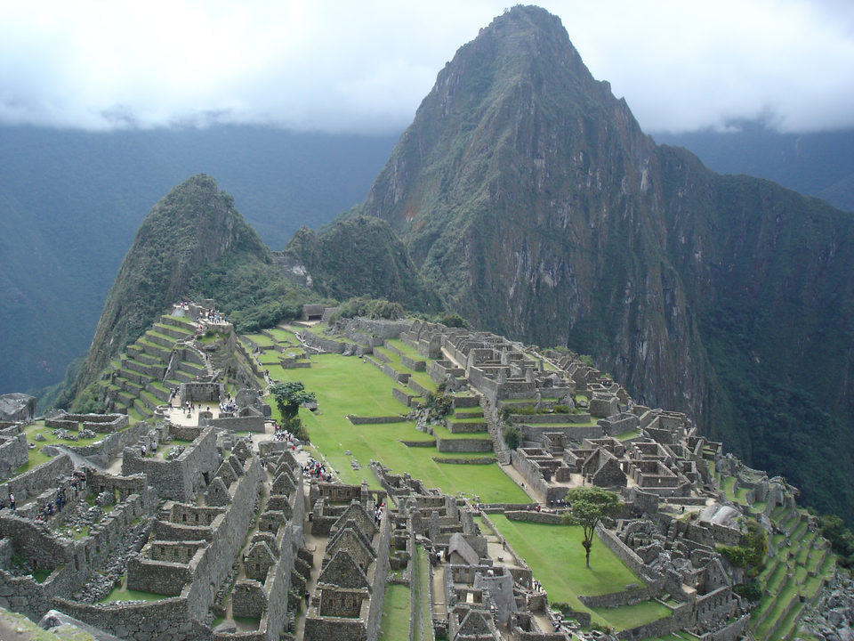
The ruins of Machu Picchu, rediscovered in 1911 by Yale archaeologist Hiram Bingham, are one of the most beautiful and enigmatic ancient sites in the world. While the Inca people certainly used the Andean mountain top (9060 feet elevation), erecting many hundreds of stone structures from the early 1400's, legends and myths indicate that Machu Picchu (meaning 'Old Peak' in the Quechua language) was revered as a sacred place from a far earlier time. Whatever its origins, the Inca turned the site into a small (5 square miles) but extraordinary city. Invisible from below and completely self-contained, surrounded by agricultural terraces sufficient to feed the population, and watered by natural springs, Machu Picchu seems to have been utilized by the Inca as a secret ceremonial city. Two thousand feet above the rumbling Urubamba river, the cloud shrouded ruins have palaces, baths, temples, storage rooms and some 150 houses, all in a remarkable state of preservation. These structures, carved from the gray granite of the mountain top are wonders of both architectural and aesthetic genius. Many of the building blocks weigh 50 tons or more yet are so precisely sculpted and fitted together with such exactitude that the mortarless joints will not permit the insertion of even a thin knife blade. Little is known of the social or religious use of the site during Inca times. The skeletal remains of ten females to one male had led to the casual assumption that the site may have been a sanctuary for the training of priestesses and /or brides for the Inca nobility. However, subsequent osteological examination of the bones revealed an equal number of male bones, thereby indicating that Machu Picchu was not exclusively a temple or dwelling place of women.

One of Machu Picchu's primary functions was that of astronomical observatory. The Intihuatana stone (meaning 'Hitching Post of the Sun') has been shown to be a precise indicator of the date of the two equinoxes and other significant celestial periods. The Intihuatana (also called the Saywa or Sukhanka stone) is designed to hitch the sun at the two equinoxes, not at the solstice (as is stated in some tourist literature and new-age books). At midday on March 21st and September 21st, the sun stands almost directly above the pillar, creating no shadow at all. At this precise moment the sun "sits with all his might upon the pillar" and is for a moment "tied" to the rock. At these periods, the Incas held ceremonies at the stone in which they "tied the sun" to halt its northward movement in the sky. There is also an Intihuatana alignment with the December solstice (the summer solstice of the southern hemisphere), when at sunset the sun sinks behind Pumasillo (the Puma's claw), the most sacred mountain of the western Vilcabamba range, but the shrine itself is primarily equinoctial.

Shamanic legends tell that when a sensitive person touches their forehead to the Intihuatana stone it opens their vision to the spirit world. Intihuatana stones were the supremely sacred objects of the Inca people and were systematically searched for and destroyed by the Spaniards. When the Intihuatana stone was broken at an Inca shrine, the Inca believed that the deities of the place died or departed. The Spaniards never found Machu Picchu, even though they suspected its existence, thus the Intihuatana stone and its resident spirits remain in their original position. The mountain top sanctuary fell into disuse and was abandoned some forty years after the Spanish took Cuzco in 1533. Supply lines linking the many Inca social centers were disrupted and the great empire came to an end. The photograph shows the ruins of Machu Picchu in the foreground with the sacred peak of Wayna Picchu towering behind. Partway down the northern side of Wayna Picchu is the so-called "Temple of the Moon" inside a cavern. As with the ruins of Machu Picchu, there is no archaeological or iconographical evidence to substantiate the "new-age" assumption that this cave was a goddess site.

Although Hiram Bingham was the first person to bring word of the ruins to the outside world in 1911, other outsiders were said to have seen Machu Picchu before him. The site may have been discovered in 1867 by a German businessman, Augusto Berns, and there is some evidence that another German, J. M. von Hassel, arrived even earlier. Maps found by historians show references to Machu Picchu as early as 1874. In 1904, an engineer named Franklin supposedly spotted the ruins from a distant mountain.


The INCA and their History

At the time of Columbus’ landfall on the New World, the greatest empire on earth was that of the Inca. Called Tawantinsuyu or ‘Land of the Four Quarters,’ it spanned more than 4300 miles along the mountains and coastal deserts of central South America. The vast empire stretched from central Chile to present Ecuador-Colombia border and included most of Peru, Bolivia, Ecuador, northern Chile and northwestern Argentina (this is a land area equal to the entire portion of the United States from Maine to Florida east of the Appalachians). It exceeded in size any medieval or contemporary European nation and equaled the longitudinal expanse of the Roman Empire. Yet for all its greatness, Tawantinsuyu existed for barely a century.

The origins of the Inca are shrouded in mystery and mythology. According to their own mythology, the Inca began when Manco Capac and his sister, Mama Occlo, rose out of Lake Titicaca, having been created by the Sun and the Moon as divine founders of a chosen people. Manco Capac and his sister then went off with a golden rod to find a suitable location to found a great city. Through a series of adventures, geomantic resonances, and astronomical correspondences, the site of Cuzco was chosen.

Archaeological research, on the other hand, indicates that the pre-imperial Inca were simply one of a number of petty tribes in the south central region of Peru. From roughly 1200 AD to the early 1400’s, the Inca engaged in numerous battles with local rivals, but never achieved supremacy over any of them. Around 1438, however, the Inca emperor Viracocha and his son, Pachakuti, defeated a powerful rival, the Chankas. From this time the empire building era of the Inca began. Other rival tribes around the Cuzco area were soon united and campaigns were launched into the Titicaca basin and beyond. During the ensuing reigns of the emperors Pachakuti, and Topa Inca the Inca armies expanded the frontiers of Tawantinsuyu from southern Columbia to central Chile.

In the few short years before their overthrow by the Spanish in 1532, the Inca developed one of the largest and most sophisticated empires in the entire pre-industrial world. (In discussing Inca achievements, however, it is important to state that they were not the singular invention of a few inspired emperors but rather the ultimate elaboration of numerous pan-Andean institutions.) The Inca accomplished their phenomenal growth through a mixture of diplomacy and warfare, and a sociopolitical management system based on highly effective taxation and the dependable provision of goods and services to the peoples of their realm.

As the Inca began to expand their territories, the first step was to seek alliances with tribes upon the frontiers. Copious gifts of textiles, exotic products from distant regions, and wives to add blood ties to the alliances were offered to the chiefs of these tribes. Quite frequently these gifts were readily accepted (certainly the intimidating specter of the powerful Inca armies assisted in this process), but if certain tribes proved recalcitrant, the Inca simply overwhelmed them with superior military power.

In either case, the tribes were then incorporated into larger administrative units and political provinces. This strategy left Tawantinsuyu with more than 80 political provinces, each with different ethnic and linguistic characteristics. To address these regional differences the Inca imposed there own tongue, Quechua, as the language of the realm and the medium of governmental communication. Additionally, the Inca frequently moved entire populations around their realm, putting loyal groups into troublesome areas, and transferring recalcitrant tribes to loyal areas. These wholesale transfers of people were also used to introduce weavers and farmers, stone workers and artisans into areas where these skills were needed.

Inca statecraft, a system of truly extraordinary efficiency, was founded upon the ancient, pan-Andean concept of reciprocity. Goods and services moved from the local area to regional and state warehouses and were then redistributed back to the populace in several important ways. The state economy was based, not on currency systems, but on extracting taxes in the form of labor. There were three primary forms to this taxation: agricultural levies on local community-managed lands; a labor service required of able-bodied males that provided for monumental construction projects and military campaigns; and the textile production required of women, children and older men. The goods and services gathered in these ways were then divided into three shares. The first third went to support Inti (the Sun god), other gods in the state pantheon, and a wide variety of ceremonial activities. The second portion went to support the Inca emperor and the construction and military projects he initiated. The third portion was redistributed to the common people in the form of food, textiles, lavish festivals, and military protection.

The most visible, and remaining, examples of Inca genius are to be found in their monumental construction projects: in the form of roads, agricultural terraces, and administrative and ceremonial structures. The vast empire was united by an extensive and superbly efficient highway system. Two parallel highways, one along the coast and the other in the high mountains, ran north-south from one end of the empire to the other. Between these two major highways ran dozens of east-west roads linking the coasts, mountains, and jungles. Altogether there were more than 30,000 kilometers of these roads, the majority of which were beautifully paved, well drained, and equipped with storage houses, travelers’ lodges, and military posts. The produce of the empire moved efficiently along these roads, transported by hardy llamas strung together in caravans of a thousand or more animals. Furthermore, along the roads sped the most rapid communication system ever developed in the pre-industrial world; in the form of a constant movement of fleet-footed runners.

To feed the people in their swiftly growing empire, the Inca terraced great areas of mountain land, transported rich soils to the terraces, employed highly sophisticated irrigation systems, and experimented with a variety of crops. These monumental landscaping projects, called andenes in the Quechua language, so impressed the colonial Spanish that they named the Andes mountains after them (recent satellite photography has shown that these Inca terraces covered more land than is currently cultivated in the central Andean nations).

In their administrative and even more so, their ceremonial centers, the Inca most clearly displayed their brilliance with design and construction. Great surviving centers such as Pisac, Ollantaytambo, Machu Picchu, and Cuzco, the Inca capital, are well known examples. In these places the Inca fashioned monumental architecture equal in beauty to any culture of the old world. Massive, multi-sided blocks were precisely fitted together in interlocking patterns in order to withstand the disastrous effects of earth quakes (in an earthquake, the stones on Inca terrace walls lock together, allowing the entire wall to simultaneously flex and cohere). Both secular and sacred architecture had spacious windows, niches for idols, and other purely artistic sculptural elaborations. Splashing fountains abounded and masterpieces of hydraulic engineering brought fresh water into buildings, while other channels removed wastes.

The Incas never used the wheel in any practical manner. Its use in toys demonstrates that the principle was well-known to them, although it was not applied in their engineering. The lack of strong draft animals, as well as steep terrain and dense vegetation issues, may have rendered the wheel impractical. How they moved and placed the enormous blocks of stones remains a mystery, although the general belief is that they used hundreds of men to push the stones up inclined planes. A few of the stones still have knobs on them that could have been used to lever them into position.

It must be noted, however, that the places mentioned above, Pisac, Ollantaytambo and Machu Picchu in particular, are known to have been ceremonial sites many centuries and even millennia before the Inca developed and, furthermore, already had existing structures that were used for astronomical observations and ceremonial functions. Many contemporary people writing and speaking about the Inca are not well enough educated to know this matter yet, none the less, it is archaeological fact.

The name of the archaeological site Machu Picchu is sometimes misspelled as machu pichu, macchu picchu, machu piccu, machupicchu, macu picchu, macho picchu, machu piccho, machu picch, macha picchu, machu piccuh, mach picchu. The correct spelling is Machu Picchu.


Source: SacredSites

Twitter Delicious Facebook Digg Stumbleupon Favorites More